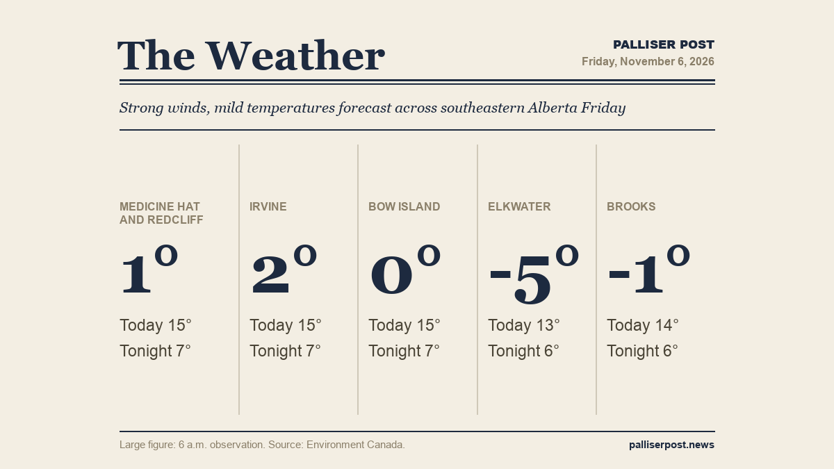
Southeastern Alberta is in for a mild but increasingly windy Friday, with Environment Canada forecasting highs of 13 to 15 C under mainly sunny skies before southwest winds build to 40 to 50 km/h with gusts of 60 to 70 km/h through the afternoon and evening. Wind chills of minus 8 are expected in the morning hours. The warm stretch continues into the weekend, with highs of 14 to 17 C Saturday and Sunday, though strong and gusty winds are expected to persist.

Medicine Hat and Redcliff

At 6 a.m. at the Medicine Hat airport, skies were clear and the temperature was 1.3 C, with a south-southwest wind at 22 km/h gusting to 32. Environment Canada calls for a sunny Friday morning giving way to a mix of sun and cloud, with a southwest wind of 20 km/h gusting to 40 increasing to 40 gusting to 60 near noon. The high will be 15 C. Wind chill of minus 8 is expected this morning. UV index is 2 or low. Friday night brings partly cloudy skies clearing overnight, a southwest wind of 40 km/h gusting to 60 and a low of 7 C.

Irvine

At 6 a.m. at Irvine, the temperature was 2.1 C with a southwest wind at 17 km/h. Environment Canada expects sunny skies to open Friday before cloud develops through the morning; southwest winds build from 20 gusting to 40 to 40 gusting to 60 near noon. The afternoon high will reach 15 C. A wind chill of minus 8 is forecast this morning and the UV index is 2 or low. Overnight, skies become partly cloudy before clearing, with a southwest wind of 40 km/h gusting to 60 holding and the temperature dropping to a low of 7 C.

Bow Island

At 6 a.m. at the Bow Island Climate station, the temperature was 0.0 C with a wind chill of minus 4, humidity at 76 per cent and a south-southwest wind at 12 km/h. The forecast calls for a mainly sunny day with a mix of sun and cloud developing through the morning. Southwest winds increase from 20 gusting to 40 up to 40 gusting to 60 near noon. High of 15 C. Wind chill of minus 8 this morning; UV index 2 or low. Partly cloudy skies overnight with a southwest wind of 40 km/h gusting to 60 and a low of 7 C.

Elkwater and Cypress Hills

At 6 a.m. at Lodge Creek, the temperature was minus 4.8 C with a wind chill of minus 9 and a north-northwest wind at 10 km/h. Elkwater and the Cypress Hills see the coldest start in the region Friday, though a sunny day is ahead. Clouds develop through the morning as winds shift from west at 20 gusting to 40 to southwest at 40 gusting to 60 near noon. The high will be 13 C, the lowest daytime peak in the region. Wind chill of minus 8 this morning; UV index 2 or low. Friday night is partly cloudy with a southwest wind of 40 km/h gusting to 60 and a low of 6 C.

Brooks

At 6 a.m. at Brooks, the temperature was minus 1.4 C with a wind chill of minus 4, humidity at 75 per cent and a south-southeast wind at 7 km/h. Brooks faces the strongest gusts in the region: a southwest wind of 20 gusting to 40 builds to 50 gusting to 70 this afternoon. The day will be a mix of sun and cloud with a high of 14 C. Wind chill of minus 8 this morning; UV index 1 or low. Friday night brings a few clouds, winds easing from 50 gusting to 70 to 30 gusting to 50 overnight, and a low of 6 C.

Outlook

The warm and mostly sunny pattern holds through the weekend. Environment Canada forecasts highs of 14 to 17 C Saturday, with southwest winds of 40 km/h gusting to 60 easing in the afternoon across much of the region, though Brooks sees a wind shift to southeast 20 gusting to 40 in the afternoon. Saturday night lows range from plus 2 to plus 6. Sunday brings another sunny and windy day with highs of 14 to 16 C, followed by clear overnight lows of plus 1 to plus 2.

Forecasts and observations from Environment Canada.

Share this article
The link has been copied!