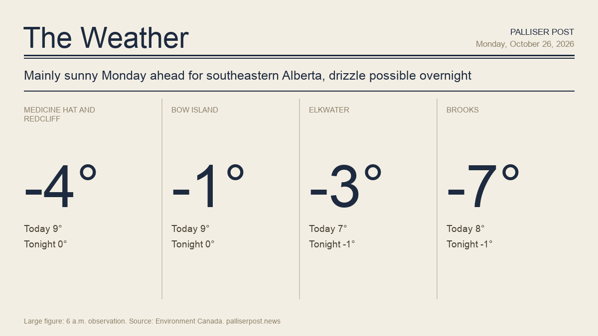
Southeastern Alberta is starting the week under partly cloudy skies and sub-zero temperatures, with wind chills in the minus 8 to minus 13 range across the region Monday morning, according to Environment Canada. Mainly sunny conditions are expected through the afternoon, with highs ranging from 7 C in the Cypress Hills to 9 C at Medicine Hat and Bow Island.

A shift arrives overnight as cloud builds and a 30 per cent chance of drizzle develops across much of the region, bringing a risk of freezing drizzle. Rain is expected to become the dominant feature by Tuesday.

Medicine Hat and Redcliff

At 6 a.m. at the Medicine Hat airport, it was minus 4.2 C under partly cloudy skies, with a north wind at 9 km/h and a wind chill of minus 8. Environment Canada is calling for a mainly sunny Monday with a southeast wind at 20 km/h and a high of 9 C; the wind chill of minus 12 will ease as the morning progresses. The UV index will be 2, or low. Monday night brings mainly cloudy skies with a 30 per cent chance of drizzle and a risk of freezing drizzle, with a southeast wind at 20 km/h becoming light by evening and a low of zero.

Bow Island

At 6 a.m. at the Bow Island Climate station, the temperature was minus 1.5 C with a southeast wind at 26 km/h producing a wind chill of minus 8. Environment Canada expects a mostly sunny day with a southeast wind at 20 km/h and a high of 9 C; the wind chill of minus 12 this morning will ease through the day. The UV index reaches 2, or low. Cloud builds overnight with a 30 per cent chance of drizzle and a risk of freezing drizzle; the southeast wind at 20 km/h will ease to light by evening and the low will be zero.

Elkwater and Cypress Hills

At 6 a.m. at Lodge Creek, the temperature was minus 3.2 C with an east-southeast wind at 21 km/h and a wind chill of minus 9. Environment Canada forecasts mainly sunny skies Monday with a southeast wind at 20 km/h and a high of 7 C — the coolest daytime high in the region. The wind chill of minus 9 will moderate through the morning. The UV index will be 2, or low. Skies become cloudy Monday evening with a 30 per cent chance of drizzle after midnight and periods of rain developing overnight; a risk of freezing rain is possible overnight. The southeast wind eases to light by evening and the low will be minus 1.

Brooks

At 6 a.m. in Brooks, the temperature was minus 6.7 C — the coldest reading in the region — with a south wind at 4 km/h and a wind chill of minus 9. Environment Canada calls for a mix of sun and cloud Monday with fog patches dissipating in the morning, a southeast wind at 20 km/h easing to light in the afternoon and a high of 8 C. The wind chill will be minus 13 this morning. The UV index will be 2, or low. Monday night will be partly cloudy with fog patches redeveloping, wind up to 15 km/h and a low of minus 1; a wind chill of minus 6 is expected overnight.

Outlook

Tuesday brings a wetter picture across the region, according to Environment Canada. Medicine Hat, Redcliff and Bow Island can expect cloudy skies with a 30 per cent chance of drizzle in the morning giving way to periods of rain, with a risk of freezing drizzle early and a high of 6 C; showers are possible again Tuesday night with a 60 per cent chance and a low of zero. Elkwater and the Cypress Hills face 5 to 10 mm of rainfall Tuesday with a risk of freezing rain in the morning, winds shifting to west at 20 km/h gusting to 40 and a high of 6 C; rain continues Tuesday night with a low of minus 2. Brooks has a 30 per cent chance of showers Tuesday afternoon and a high of plus 5, followed by cloudy skies and a low of minus 2. Wednesday turns sunny across the region with highs of plus 4 to plus 7, though Wednesday night could bring snow to Medicine Hat and Bow Island and a mix of rain or flurries for Brooks, with lows of minus 4 across the region.

Forecasts and observations from Environment Canada.

Share this article
The link has been copied!