No weather alerts are in effect for any community in the region.
Medicine Hat and Redcliff
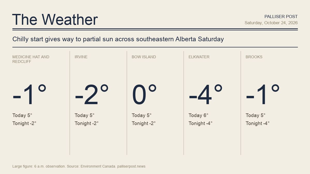
At 6 a.m. at the Medicine Hat airport, skies were cloudy and the temperature sat at minus 0.6 C, with a wind chill of minus 4 and a west-southwest wind of 11 km/h. Environment Canada calls for a mix of sun and cloud Saturday, with a west wind of 20 km/h becoming light this morning and a high of plus 5 C. The wind chill will reach minus 9 through the morning. Saturday night will be mainly cloudy with a low of minus 2 and a wind chill of minus 7 overnight. Winds up to 15 km/h. UV index 2 or low.
Irvine
At 6 a.m. at Irvine, the temperature was minus 1.9 C with a wind chill of minus 8 and a west-southwest wind of 22 km/h. Environment Canada is forecasting a mix of sun and cloud for Saturday, with winds west at 20 km/h becoming light in the morning and a high of plus 5 C. Wind chills will hit minus 9 during the morning hours. Cloud cover builds again this evening; overnight will be mainly cloudy with winds up to 15 km/h and a low of minus 2. Wind chill minus 7 overnight. UV index 2 or low.
Bow Island
Bow Island recorded a temperature of plus 0.3 C at 6 a.m. at the Bow Island Climate station, where a west-southwest wind of 8 km/h was blowing. Environment Canada expects a mix of sun and cloud through Saturday, with a west wind of 20 km/h becoming light this morning and a high of plus 5 C. A wind chill of minus 9 is forecast for the morning. Skies become partly cloudy then mainly cloudy this evening, with a low overnight of minus 2 and winds up to 15 km/h. Wind chill minus 7 overnight. UV index 2 or low.
Elkwater and Cypress Hills
The coldest reading in the region came from Lodge Creek near Elkwater, where the temperature was minus 4.0 C at 6 a.m. with a wind chill of minus 7 and a west-northwest wind of 8 km/h. Environment Canada calls for a mix of sun and cloud Saturday, with a northwest wind of 20 km/h becoming light this morning and a high of 6 C — the warmest daytime high in the region. Wind chill of minus 10 expected this morning. Saturday night will see a few clouds, winds becoming northeast at 20 km/h this evening, and a low of minus 4. Wind chill minus 10 overnight. UV index 2 or low.
Brooks
At 6 a.m. at Brooks, the temperature was minus 0.6 C with a wind chill of minus 6 and a northwest wind of 18 km/h. Brooks faces the gustiest Saturday morning conditions in the region — Environment Canada forecasts a northwest wind of 30 km/h gusting to 50, becoming light this afternoon, with cloud increasing later in the day and a high of plus 5 C. Wind chill of minus 10 is expected through the morning. Saturday night will be mainly cloudy with a low of minus 4, winds up to 15 km/h and a wind chill of minus 8 overnight. UV index 2 or low.
Outlook
Sunday brings a mix of sun and cloud to most of the region — clearing conditions near noon in Brooks — with highs of plus 2 to plus 4 C and wind chills of minus 7 to minus 10 in the morning; east winds of 20 to 30 km/h are possible in some areas. Sunday night will be clear to partly cloudy with lows of minus 4 to minus 5 C. Monday offers a return to a mix of sun and cloud with milder highs of 6 to 8 C and lows near minus 1 or minus 2 Monday night, according to Environment Canada.
Forecasts and observations from Environment Canada.